How Cumberland’s new council wards were decided
The new electoral map changes who represents neighbourhoods without moving the council’s outer boundary, and Parliament had a chance to stop it.
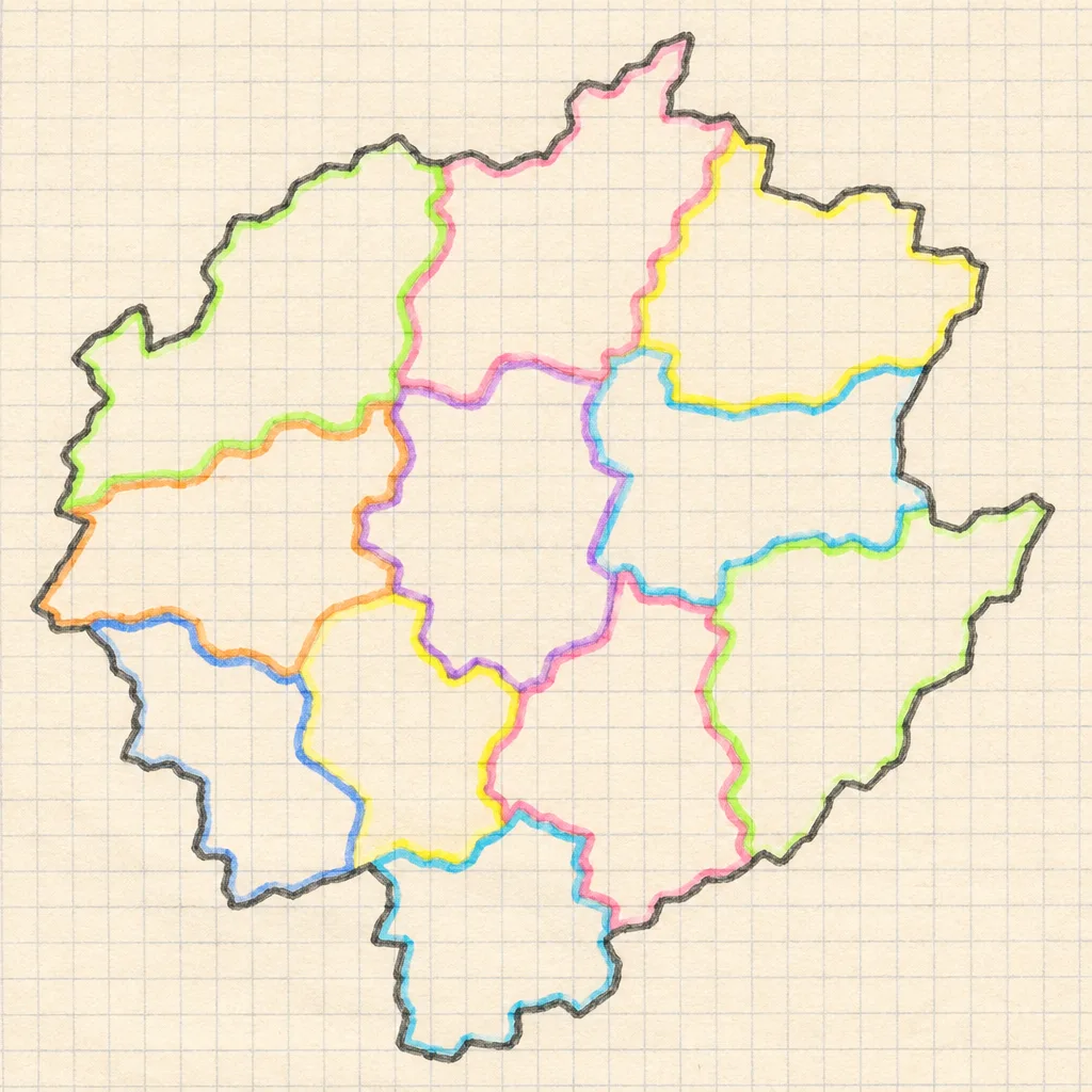
Cumberland’s electoral map is changing under an order made by the Local Government Boundary Commission for England on 4 November 2026. The order creates new wards for council elections, but its explanatory note says it does not move Cumberland’s outer boundary.
That distinction matters. A council boundary marks the outside of the area a council serves. A ward is an area within a council’s territory used to elect councillors. Think of the council area as a sheet of paper and wards as the shapes drawn inside it: you can redraw the shapes without cutting the edge of the paper.
The Cumberland order says its new map has 55 council wards, each electing one councillor. The new arrangement changes representation inside the council area; it does not, on its own, transfer a town to a neighbouring council.
There is another layer. A parish is a smaller local government area, often served by a parish or town council. A parish ward is used to elect members of that parish or town council, not members of Cumberland Council. The order creates parish wards as well as council wards, and their lines and numbers of councillors need not be the same.
Millom shows why checking the map matters. The Commission’s Millom parish map places the town inside the green Cumberland council boundary. Cumberland Council also lists Millom and Millom Without among its existing wards. The order’s inclusion of Millom is therefore not, by itself, evidence that the council boundary has moved.
On the Commission’s Millom map, the green line marks the council boundary; red lines show its recommended council wards; orange lines show parish wards. Haverigg is a parish ward within that map, while Millom is also the name of a council ward. A shared place name does not make those electoral areas identical.
To check your own address, go to the Commission’s Cumberland review page and open the map referred to in the order. Find your street and read the key before following the lines. Then check the relevant schedule, meaning the list attached to the order, for the councillor seats assigned to that ward. If a line is shown following a road, the order treats it as running along the road’s centre. A ward name alone cannot tell you which side your home is on.
Who gave the Commission this job? Parliament did. The Local Democracy, Economic Development and Construction Act 2009 established the Commission and, in section 59, gave it power to make an order implementing recommendations from an electoral review. An electoral review is an examination of arrangements such as ward boundaries and councillor numbers. The review concerns Cumberland, but the Commission made the recommendations and the order.
The law requires the Commission to consider matters including electoral equality, which means trying to give each councillor a similar number of voters to represent, alongside community identities and effective local government. For example, a line that makes voter numbers more equal might also split a community that people regard as belonging together. The Commission has to make choices between those considerations.
Its final report sets out its reasons and the submissions it received. Those forecasts show that the new wards are not expected to be exactly equal. They do not, by themselves, tell us which neighbourhoods have improved compared with the old map or which party will gain.
The order is a statutory instrument: a law made using powers granted by an Act of Parliament, rather than a new Act debated through all its stages. Before making this kind of order, the Commission must lay a draft before both Houses. That means formally presenting the text to the House of Commons and House of Lords.
Here is the crucial word: the procedure is called draft negative. Either House could have passed a formal decision rejecting the draft during the permitted period. If one had done so, this draft could not have been made, although a new draft could have been presented. Neither House had to hold a vote approving it for the Commission to proceed.
The Act’s explanatory notes say the period is 40 days, but not every calendar day counts. The Statutory Instruments Act 1946 excludes, for example, periods when both Houses are adjourned for more than four days. That is why counting weeks on a calendar is not enough to check the deadline.
The order itself states that the required period expired without either House rejecting it. The parliamentary tracker and the Commission’s page do not agree on the laying date; the tracker’s deadline and the order’s statement are separate things you can check.
The Commission has obtained the arrangements it recommended. Cumberland’s election administrators must prepare for them, but the order’s explanatory note gives no figure for that work: it says no full impact assessment was produced because no significant impact was foreseen. That is not the same as an itemised cost, and it does not establish whether any party or community will benefit.
Finally, a law can be made on one date and operate on different dates for different purposes. The order says its title and map rules began on 5 November 2026. Its ward provisions also began then for election preparations, so officials can organise the coming contests using the new arrangements. For other purposes those provisions take effect on the ordinary election day in 2027. Early preparation does not mean every effect of the new wards happened at once.

Keep going
 How it works
What Wales’s automatic voter registration means
A notice about council elections does not mean you are registered for UK Parliament elections, and you have choices before your name is added.
 How it works
What the Microsoft outage reveals about the cloud
Sussex’s email disruption shows how an organisation’s choice of provider can affect students, while leaving other services working.
 How it works
What a phoenix company is, and what it is not
The Insolvency Service wants earlier action on abusive phoenixism, but a business restart is not automatically fraud.